**Zoom Earth: Your Interactive Gateway to Real-Time Weather and Environmental Monitoring
In an era where climate awareness and weather preparedness are critical, Zoom Earth emerges as a powerful, user-friendly platform for tracking global weather patterns, environmental changes, and extreme events. Developed by Neave Interactive, this web-based tool combines real-time satellite imagery, advanced weather modeling, and interactive features to deliver a comprehensive view of our planet’s dynamic systems[1]. Whether you’re a weather enthusiast, researcher, or simply curious about the skies above, here’s how Zoom Earth can empower your understanding of Earth’s weather and climate.
What Is Zoom Earth?
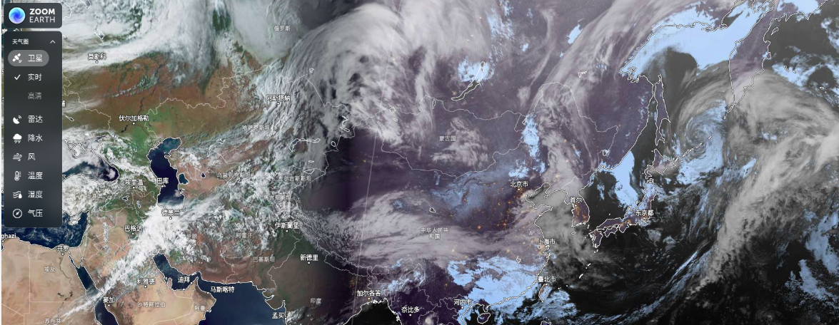
Zoom Earth is an interactive global weather map that integrates live satellite imagery, radar data, and forecasting models to visualize weather events and environmental conditions. Unlike traditional weather apps, it offers a bird’s-eye view of Earth with tools tailored for both casual users and professionals.
Key Features of Zoom Earth
-
Real-Time Satellite Imagery
Zoom Earth provides near-live satellite views of cloud cover, storms, and terrain using data from NOAA GOES, JMA Himawari, and EUMETSAT satellites[1]. Images refresh every 10–15 minutes with a minimal delay of 20–40 minutes, ensuring up-to-date insights[1][6]. Toggle layers like “HD” for clearer visuals or “Radar” to overlay precipitation patterns. -
Dynamic Weather Forecasting
- Rain and Snow Radar: Track live precipitation with radar maps that predict short-term weather shifts, ideal for planning outdoor activities or storm preparedness[1].
- Wind and Temperature Maps: Visualize global wind speed, gusts, temperature, and humidity using data from DWD ICON and NOAA GFS models[1].
- Atmospheric Pressure Forecasts: Monitor sea-level pressure trends to anticipate weather systems like cyclones or high-pressure zones[1].
-
Extreme Event Tracking
- Hurricanes and Cyclones: Follow the path and intensity of tropical storms with real-time updates and historical data[1].
- Wildfire Monitoring: Detect active fires and smoke movement using satellite-detected hotspots and GeoColor imagery[1].
-
Climate Change Insights
Researchers use Zoom Earth to observe long-term environmental shifts, such as glacier retreat or deforestation, by comparing historical and current satellite data[1]. -
Customizable Tools
- Layer Overlays: Combine cloud cover, precipitation, wind, and temperature data for a holistic view[2].
- Alerts and Notifications: Set custom alerts for extreme weather in specific regions[2].
How to Use Zoom Earth
-
Access the Platform
Visit Zoom Earth directly from your browser—no installation required. -
Navigate the Interface
- Use the toolbar on the left to toggle satellite layers (e.g., radar, wind, temperature).
- Zoom in/out with your mouse or the +/- buttons.
- Click the search icon to jump to a specific location.
-
Track Weather Events
- For hurricanes, type the storm’s name in the search bar or browse the “Tropical Cyclones” section.
- For wildfires, enable the “Fires” layer to view hotspots and smoke trails.
-
Save and Share Views
Use the screenshot tool to capture maps or share links to specific weather patterns.
Why Zoom Earth Stands Out
Zoom Earth bridges the gap between scientific accuracy and public accessibility. Its reliance on authoritative data sources (e.g., NOAA, DWD) ensures reliability, while features like offline map access and customizable alerts cater to diverse needs[1][2]. For educators, it’s a vivid tool to explain climate systems; for travelers, it’s a lifeline for weather-aware planning.
Final Thoughts
From tracking a brewing storm to studying the planet’s evolving climate, Zoom Earth transforms complex data into actionable insights. Its intuitive design and real-time capabilities make it an indispensable resource for anyone keen to explore Earth’s ever-changing atmosphere.
Explore Zoom Earth today: https://zoom.earth/
[1] Zoom Earth(实时卫星地图与天气预报综合服务平台)-百科
[2] zoomearth风暴追踪器下载安装-zoomearth风暴追踪器...- 艾特游戏网
[6] 每10分钟一更新的实时卫星影像